
2018-2019 WINTER FORECAST
/Review of 2017-2018 Forecast
Overall last winter unfolded fairly close to what we expected. We expected a few very cold shots of weather into January-February as well as a few chances for some large events across NC. For the most part that panned out!
Lets take a look at our temperature forecasts from last winter to see how they verified!
December
We were off with the below normal placement as the NE ended up being cold. But for NC we were very accurate.

January
This was our bad month.
We thought the Eastern US would see the bulk of the warmth. In reality some large winter systems allowed the cold to sink south and give the East Coast some cold temps.
We knew this month would have one half of the US cold and the other hot. We just completely got the call backwards.

February
We forecasted a quick end to winter as February came in and that's exactly what happened.
A ridge setup over the Eastern US and brought near record warmth to many areas in the South.

March
March we saw the signs for a cool March in the East and a warm March in the West. The actual warmth area setup more in the South-Central area but overall it was fairly close.

2018-2019 Winter Forecast Key Factors
ENSO (La Nina or El Nino)
Look at the black box. This is the ENSO region. It is a major driving factor for weather across the US.
Notice that the black box is mostly above average. This means that the ENSO region is in a state of El Nino.
A significant factor for this winter is how much of the warmth in the box is on the western side. This indicates a Modoki Nino event. A Modoki Nino is simply an El Nino with most of the warmth in the western portion of the region.
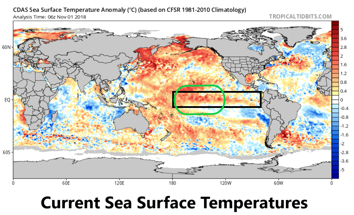
SST map from Tropicaltidbits.com
East Nino Vs Modoki (Central) Nino
Here are the two types of Nino. Modoki (central) Nino has most of the warm water centered in the middle of the ENSO region exactly like this year.
East Nino is the traditional Nino and you can see most of the warmth is close to the South American coast.

A product of NOAA.
What does this mean for the US winter?
A Central (Modoki) Nino tends to focus the cold weather on the Eastern side of the US. So you have a warm West US and a cold East US.
An East Nino tends to spread out the cold across most of the country.
This winter we expect a Central (Modoki) Nino.
This means that a lot of the cold will be centered on the East Coast while the West Coast may be warmer than usual.
Low Solar Activity
A very important factor this winter is the cycle of sun activity. We are approaching a solar minimum right now which is when the number of sunspots on the sun are non-existent or close to it.

In winters with low solar activity it is more likely to have blocking in the Northern Hemisphere. Blocking is the key element to push storms and cold south out of Canada and into the US.
Key Points
Modoki Nino: This is the “optimal” pattern for a cold and snowy Eastern US.
Low Solar Activity: This can increase the chance of blocking and help funnel cold into the US.
2018-2019 Winter Month by Month
Lets go month by month starting with December 2018.
December 2018
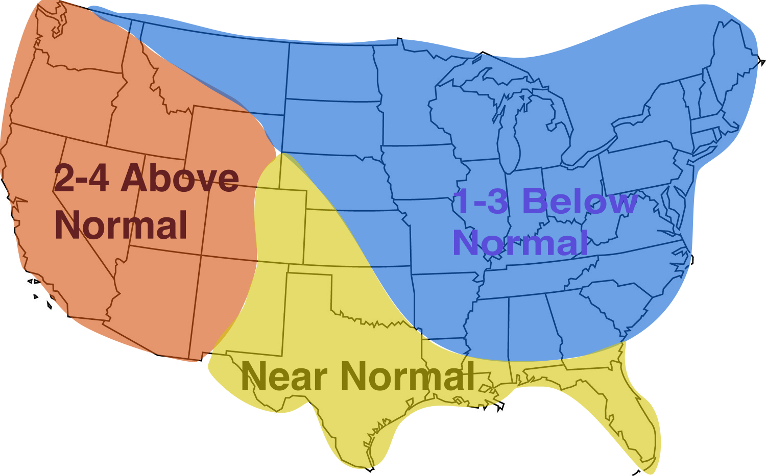
Out of all the months December is probably the toughest one to forecast! Some recent El Niño years have had very warm December temperatures for most of the US. However El Niño years that match closer to the expected pattern for this winter feature cooler December temperatures across the Eastern US. For December we are going with this theme of a cooler Eastern US with a warmer Western US but confidence is low.

Our December 2018 forecast - Confidence is low
January 2019
For January we are expecting a bit more of a colder pattern especially the second half of January when things should begin to shift even colder as we approach February. January is typically one of our snowiest months and snow/ice chances should be good for the month of January.
Our January 2019 forecast with colder temperatures across the Eastern US
February 2019
This could be the coldest and most brutal month this winter. All the data is pointing to a brutally cold month in February. Historically the El Niño produces cold February temperatures and the enhanced blocking from the low solar activity could make it even colder. Snow and ice threats will be likely.

February 2019 could be a brutally cold month across the Eastern US
March 2019
March is a bit of a trickier month to forecast as well. If the El Niño hangs on long enough it could be a cooler than normal month for much of the US. However, if a La Niña begins to build or the El Niño weakens quickly then riding could begin to take shape across the Eastern US and warm things up some. Orr forecast is a blend that favors a colder Western US and normal to slightly above normal for parts of the Eastern US.

March 2019 with a cooler Western US and a possible ridge taking over the Eastern US to warm things up
Snow and Ice Chances?
What type of snow and ice chances can we expect for this winter? El Niño winters usually favor enhanced precipitation across the Southern US and cooler weather especially in January and February.
There will be a chance for several BIG snow threats with this pattern setup. As always it will all depend on the exact track, amount of cold air and other details to determine who gets hit with the big snows. If you like snow you could not ask for a better pattern setup than what it looks like we will have for this winter. This does not guarantee snow but certainly enhances our chances of seeing a big one!
The ice threat is also increased especially in the month of February when warmer air aloft will try to overcome the colder air at the surface. This would favor snow events that mix with or change quickly to ice especially in the regions of NC that are especially prone to ice storms (Western and parts of Central NC).
Summary
Overall the Modoki El Niño along with low solar activity should bring with it a favorable pattern in the heart of winter for snow and ice chances along with sustained cold.